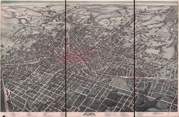
Historic 1892 Map of Atlanta, Georgia. The map is titled "Birds Eye View of Atlanta." This 1892 historic Atlanta map is extremely detailed and prints best at larger sizes. The map includes a large number of historic landmarks, including the Georgia State Capitol, Union Passenger Depot, Brisbine Park, Grand Opera House and Georgia School of Technology.
Historic Atlanta Map, 1892 Product Details
Hassle-Free 30-Day Returns
Paper Prints: Premium matte, 200 gsm (80 lb). Printed with borders. Image & paper dimensions don't always match. Printed sizes below for Historic Atlanta Map, 1892.
• 8"x10" paper with .5" border = 5.9"x9" image
• 11"x17" paper has .5" border = 10.5"x16" image
• 16"x20" paper has 1" border = 11.8"x18" image
• 24"x32" paper has 1.5" border = 19.0"x29" image
• 30"x40" paper has 2" border = 23.6"x36" image
Canvas: No borders, mounted. Image aspect ratio adjusted to fit sheet dimensions.
Aluminum Prints: No borders. Image aspect ratio adjusted to fit sheet dimensions.
Frames: Custom made. Acid-free mats, UV-shielding plexiglass. 3-5 weeks for delivery. Frame sales final.
T-Shirts: Custom made 100% cotton. Shoulder taping, double stitched sleeves. T-shirt sales final.
All Sizes: Inches
• Learn more