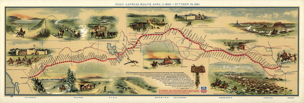
A map of the Pony Express: 'Pony Express Route April 3, 1860 - October 24, 1861. This pictographic map is made available through the generous cooperation of the Union Pacific, the first transcontinental railroad, whose lines closely parallel most of the historic Pony Express Route.'
Pony Express Map Product Details
Hassle-Free 30-Day Returns
Paper Prints: Premium matte, 200 gsm (80 lb). Printed with borders. Image & paper dimensions don't always match. Printed sizes below for Pony Express Map.
• 8"x10" paper with .5" border = 3.1"x9" image
• 11"x17" paper has .5" border = 5.4"x16" image
• 16"x20" paper has 1" border = 6.1"x18" image
• 24"x32" paper has 1.5" border = 9.9"x29" image
• 30"x40" paper has 2" border = 12.2"x36" image
Canvas: No borders, mounted. Image aspect ratio adjusted to fit sheet dimensions.
Aluminum Prints: No borders. Image aspect ratio adjusted to fit sheet dimensions.
Frames: Custom made. Acid-free mats, UV-shielding plexiglass. 3-5 weeks for delivery. Frame sales final.
T-Shirts: Custom made 100% cotton. Shoulder taping, double stitched sleeves. T-shirt sales final.
All Sizes: Inches
• Learn more